Map of Europe
This
map shows the location of the five campaign areas.
Each
square is a military region.
The
current location of each army group is shown.
The
stars show the location of previous phases.
The
colour indicates which side won.
This
is the 81st phase since the campaign started in April 2009.
It
is the 8th in the sixth revision which started in June 2020
The white star shows the location of Gera
Map of Germany
This
map shows the location of the six army groups in Germany.
Each
square is a military district.
Nine
squares is a military region.
The
stars show the location of previous campaigns fought in Germany.
The
colour of the star indicates which side won.
The
white star shows the location of Gera
There
are three allied armies would concentrate in Germany
Prussian
army at Berlin
Russian
army at Dresden
Austrian
army at Vienna
Their
objective is to defeat Napoleon
General
Wittgenstein commands the Russian army
They
are concentrated in the Dresden region
Their
objective is to march into the Erfurt region and engage the French
Marshal
Davout commands the Second French army
They
are concentrated in the Osnabruck region
Their objective is to march into the Erfurt region and engage the Prussians
Map of Central
Germany
This
map shows the location of the French and Russian army.
Each
square is a military district.
Nine
squares is a military region.
The
stars show the location of previous campaigns fought in Central Germany.
The
colour of the star indicates which side won
There
are three regions in Central Germany
Dusseldorf
Region (on the left) is held by the French army
Dresden
Region (on the right) is the held by the Russian
Erfurt
Region is the disputed area in the middle
This
map shows the current location of the French and Russian armies.
Gera is indicated by a white star
Erfurt Region
This
map shows the location of the French and Russian army.
Each
square is a military district.
Nine
squares is a military region.
This map is used for strategic (planning) movement.
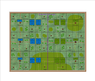
Gera District
This
map shows the campaign area
It
covers the area between Erfurt and Gera
The
district border is in the middle of the map
Each
square is a 2x2 foot scenic square.
Nine
squares is a wargames table.
Nine
squares is also a military district.
This map is used for tactical (daily)
movement
The French objective is to take and hold the
city of Gera
The Russian objective is to defeat the French
and hold Gera
Campaign Diary
01
February 1813 Austria, Britain, Prussia
and Russia declared war on France
01
February 1813 Formation of Second
French army in Dusseldorf region
26
February 1813 Second French army
declared operational.
27
February 1813 The Russians moved into
the Erfurt region
28
February 1813 Davout entered Erfurt
region and occupied Fulda district
14
March 1813 Start of Erfurt campaign
phase
21
March 1813 French win Erfurt
campaign phase
01
April 1813 Start of Gera
campaign phase
Second French Army
Marshal
Davout
2nd
Young Guard corps
6th
French corps
7th
French corps
8th
French corps
14th Westphalian corps
Each
corps has four infantry brigades, one cavalry brigade and corps artillery
80000
infantry, 5000 cavalry, 150 guns
Russian Army
General
Wittgenstein
1st
Russian corps
2nd
Russian corps
3rd
Russian corps
4th
Russian corps
5th
Russian corps
6th Russian corps
Each
corps has four infantry brigades, one cavalry brigade and corps artillery
80000
infantry, 5000 cavalry, 150 guns
Reference
The campaign diary contains comprehensive details of the whole campaign. The labels on the right are an index to various parts of the campaign.
01 - Introduction to the1813 campaign
02 - Five campaign
areas
20 - Introduction to
the campaign in Central Germany
21 - Second French
Army order of battle
22 - Russian Army
order of battle
23 - Daily diary for
the campaign in Central Germany
24 - Battle reports
of all battles fought in Central Germany
25 - Summary of campaign in Central Germany


No comments:
Post a Comment